Adventure Miles: People, place, and an unpaved road home to Yosemite
Yosemite. Majestic glacier-carved granite. Views for days. And on most roads, cars galore, tour buses, and recreational vehicles with “1-800-2RENTME” emblazoned across the back. The drivers, more focused on views than the road, can be frightening for a bicyclist. There’s an untrammeled road into the valley, however. One needs wider bike tires and the desire to work for it, though. The road less traveled is mostly dirt and climby. It also happened to be a road to my birthplace. Traversing a car-free road into Yosemite afforded me an opportunity to reflect upon people and place, birth and death, national parks and original peoples’ displacement. A little light reflection following a year of lockdown.
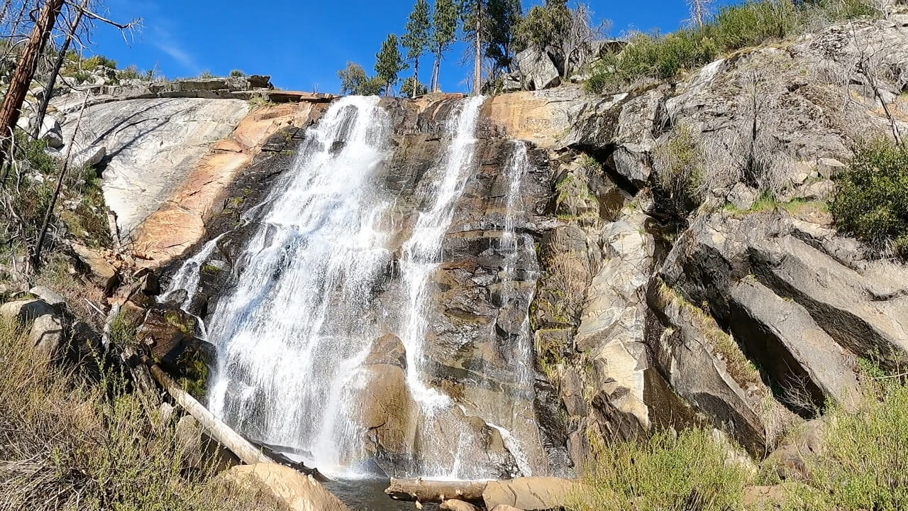 First waterfall on the Foresta-El Portal descent.
The Coulterville-Yosemite Road was the first stagecoach route into Yosemite Valley. First to market does not guarantee success, however. Originally opened in 1874 as a toll road, the route ultimately lost out to the competing toll road to the north and the competing toll road to the south. Those toll roads in turn faltered when a railroad line punched its way up the Merced River grade. The northern and southern routes were taken over by the state and are, for the most part, today’s Highway 120 out of Groveland and Highway 41 out of Oakhurst. The Coulterville-Yosemite Road fell by the wayside, forgotten by most. It runs through county, US Forest Service, and National Park Service land. An old dirt road, through parts little traveled, with deep history.
Having been born in Yosemite with roots in the area going back four generations, you would think I’d be familiar with the road. But the first I had heard about it was by coming across it in a newspaper article years ago. Given an elevation range from 1,200′ to just over 5,400′, the route is snow-risky in winter and deathly hot in summer. I had an opening in late April, making an easterly detour on a trip down to Los Angeles. Time enough for a one-day loop. I duplicated the route the Chronicle author described, parking the rental car at the bottom of the Briceberg grade along the Merced River. I then climbed Burma Grade, headed north to the Old Coulterville-Yosemite Road, then east to Foresta, descended a decaying road 2,300′ to El Portal, and then sailed along the Merced River on the 140’s slight downgrade back to Briceberg. The last 16 miles travel along a two-lane highway with limited shoulder, but with a downgrade and generally civilized drivers, they don’t feel horribly exposed.
The most thorough research
Like many intrepid adventurers, particularly those traveling alone, I did what I mistakenly thought was thorough terrain research. More on that later. Using Strava’s segment explore feature, I located a relatively large group that had ridden the same route the previous June. One of the riders took tons of photos and provided a detailed write-up. This helped tremendously in understanding the terrain, including tire decisions and hydration. That group sustained numerous flats, with one rider on a road bike. I thought a solo rider, untethered from large group rides’ inherent cumulative delays, would be faster than the group’s 10.5-hour evolution. The mountains punished me for that hubris.
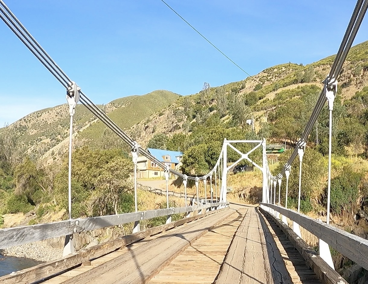 Bridge at Briceburg across Merced River to Burma Grade.
I overnighted at the Yosemite Bug Rustic Mountain Resort, a funky hostel in Midpines. Welcoming, cheap, close to the start, and familiar. It was only a few miles from where my grandparents moved after retiring from working in Yosemite for the Yosemite Park and Curry Company. Waking early to avoid the forecasted 90-degree heat, I checked out, thinking I would finish the ride mid-afternoon and head straight for Los Angeles, my ultimate destination. I would instead find myself gratefully accepting another night at the Bug at the end of a very, very long day.
Lost in the trees
The climbing flattened out a little over 5,000′. The road bit into the mountainside, serpentining in and out of steep chutes. This spectacular terrain was marked with the beginnings of granite. I began to hit my stride. With the challenging climbs behind me, I thought the rest would be relatively easy.
A little routing explanation: The official Old Coulterville-Yosemite Road splits to the left at a five-way intersection, heading northeast before ending at the Merced Grove at Highway 120. This is a good connector if one plans to tackle the Tioga Pass Road to the East Side. The 120 will also take one into Yosemite Valley. That’s not a terrible way to go but there’s more road exposure with cars and RVs, their drivers frequently overwhelmed by their first views of the Valley.
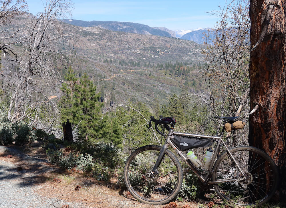 Astounding vistas amidst downed trees.
To stay on the dirt, one shifts from the Old Coulterville-Yosemite Road onto Forest Road 1S12. As I rounded a corner along Forest Road 1S12, the route seemed to disappear behind several downed trees. Easy became uneasy. I clambered over the five downed trees. As I lowered my bike down on the far side, I saw more downed trees ahead. And so it began. Ride a little, clamber a lot. Many of the trees were charred, burned in the 2013 Rim Fire. I would later remember that a January windstorm, so severe it earned the name Mono Wind Event, closed Yosemite for weeks early in the year. The wind blasted down trees, and this area had not yet been cleared.
The downed tree issue was notably absent from my route research. I knew I was roughly four miles from Foresta, where there would be an easy out. I continued forward. Those four miles took roughly four hours. There are frequently moments on epic rides that test one’s mettle. This tested mine. The section had its moments, like when I startled a bear and it crashed into the underbrush. Not a great place to be dancing with a bear, given I was progressing at an average of one mile an hour. The best moment was reaching Little Nellie Falls, crossing the creek, and putting the downed tree challenges behind me.
Bridge out ahead
A brutal but short climb from Little Nellie Falls was marked by a formal sign marking the Yosemite National Park boundary. Shortly after that the roads transformed into manicured gravel, maintained by Foresta’s residents. Foresta is a rare private home inholding within the national park itself. The plateau has a view up the valley. I took an obligatory selfie with Half Dome in the background, looking somewhat worse for wear.
One can climb the Foresta road to the 120 and then use the road to drop into the valley. If the Yosemite Valley is the ultimate destination, this is a direct valley route. The descent makes the vehicles palatable, and the tunnels and views are energizing. This will also quickly connect one to the 140 and back down the Merced gorge if one happens to be done with dirt for the day.
The alternative is the old Foresta-El Portal road. Despite all the “Bridge out!” warnings, the route is passable on foot or bike. It is, however, no longer a road. It is single-track that descends roughly 2,300′ over six miles, with several dismounts along the way. It is also overgrown, with a touch of poison oak. The single track and bridge crossings are worth the risk, though, particularly if one has a poison oak remover like Tecnu back at the car.
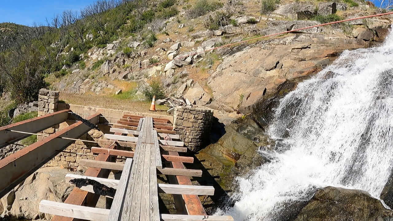 Mind your step crossing the Foresta-El Portal descent’s second bridge.
This being an adventure, I picked the Foresta-El Portal single track instead of the paved road. I bumped down the trail. As I nervously glanced left and right for poison oak, I nearly ran over a gopher snake. A good reminder to pay attention. Gopher snakes are not the only mountain reptiles. The encounter reminded me of a story my father told me. At the end of a long day fishing a known rattlesnake area, he said to his father, my grandfather, “We didn’t see any rattlesnakes today, Dad!” Without missing a beat, my grandfather replied, “Yes, but how many saw us?”
By the time I arrived in El Portal, my bottles were drained, my body battered. The Park Service employees now live in El Portal, out of the valley proper. A few rangers were milling about in front of an administration building with a hose bib. They let me refill my bottles with sufficient water for the remaining road push.
Considering the route?
Conditions: Contact the United States Forest Service for road condition updates, particularly for whether those pesky downed trees have been cleared.
Weather: The county keeps county roads clear starting May 1. Heat is the killer, so late spring or early fall are best. Water refills can get dicey in the fall. Given the portions over 5,000′, winter is not advised.
Water: Bring a water filter, Steri-Pen, or iodine. The only water is creek water for the majority of the ride.
Communications: Cell service is not consistent, and there are very few people in the back country. A satellite communicator like a Garmin InReach gives one some security with satellite texting and an emergency help button. Downloading an offline version of the region through Google Maps also provides user-friendly navigation without cellular connection.
Bike/tires: I used a gravel bike with a good climbing ratio. Tires were 42 cm in front, 35 cm in back, both fast-rolling knobbies. The combination worked for 98% of the route, ignoring the downed trees. The 2% was the exceedingly steep and mushy climb out of Little Nellie Falls toward Foresta, and a few mountain bike-level bumps along the Foresta-El Portal descent.
Options: A rider can opt for the Foresta to El Portal single track descent (mind that second bridge!) or the Foresta road up to the road to Yosemite Valley. The single track is the most technically challenging riding on the route, and one should stay vigilant for poison oak and snakes. As someone highly reactive to poison oak, I rode it and was fine but did a Tecnu decontamination at the end of the ride as a precaution.
Add-ons: For those with time and talent, this can be turned into a multi-day bikepacking trip mustering out of the Merced Amtrak station. A bit of urban and rural riding will get one to Coulterville. Alternately, one can connect at the station to YARTS — Yosemite Area Regional Transit — to reduce the road mileage. YARTS takes reservations and bikes, reservations recommended.
Have you or someone you know been involved in a bicycle crash? Curious about your rights? Are you a lawyer handling a bicycle crash who wants more information on how to get the best result for your client? Contact Bicycle Law at (866) 835-6529 or info@bicyclelaw.com.
Bicycle Law’s Bob Mionske is licensed to practice in Oregon, its affiliate Coopers LLP has lawyers licensed in California, and either can affiliate with local counsel on bicycle cases across the country to make sure cyclists get the benefit of lawyers who focus on the issues specific to bicycle incidents.
Considering the route?
Conditions: Contact the United States Forest Service for road condition updates, particularly for whether those pesky downed trees have been cleared.
Weather: The county keeps county roads clear starting May 1. Heat is the killer, so late spring or early fall are best. Water refills can get dicey in the fall. Given the portions over 5,000′, winter is not advised.
Water: Bring a water filter, Steri-Pen, or iodine. The only water is creek water for the majority of the ride.
Communications: Cell service is not consistent, and there are very few people in the back country. A satellite communicator like a Garmin InReach gives one some security with satellite texting and an emergency help button. Downloading an offline version of the region through Google Maps also provides user-friendly navigation without cellular connection.
Bike/tires: I used a gravel bike with a good climbing ratio. Tires were 42 cm in front, 35 cm in back, both fast-rolling knobbies. The combination worked for 98% of the route, ignoring the downed trees. The 2% was the exceedingly steep and mushy climb out of Little Nellie Falls toward Foresta, and a few mountain bike-level bumps along the Foresta-El Portal descent.
Options: A rider can opt for the Foresta to El Portal single track descent (mind that second bridge!) or the Foresta road up to the road to Yosemite Valley. The single track is the most technically challenging riding on the route, and one should stay vigilant for poison oak and snakes. As someone highly reactive to poison oak, I rode it and was fine but did a Tecnu decontamination at the end of the ride as a precaution.
Add-ons: For those with time and talent, this can be turned into a multi-day bikepacking trip mustering out of the Merced Amtrak station. A bit of urban and rural riding will get one to Coulterville. Alternately, one can connect at the station to YARTS — Yosemite Area Regional Transit — to reduce the road mileage. YARTS takes reservations and bikes, reservations recommended.